
occupying massachusetts
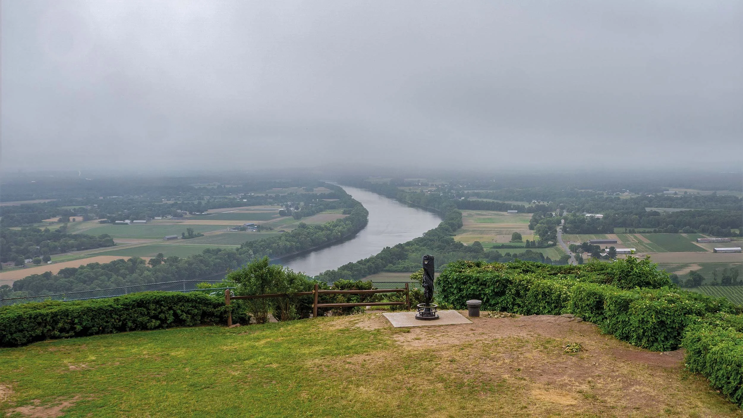
On Nipmuc and Pocumtuck homelands. Overlooking the Connecticut/Kwinitekw River from Mount Sugarloaf, also known as Wequamps, 2020. ©Sandra Matthews
The idea for my book, Occupying Massachusetts: Layers of History on Indigenous Land, came to me in 2015, when I was photographing architectural structures and decided to take a tour of an 18th century house. The tour guide spoke at length about the importance of the house in the war between the English colonists and British soldiers, and mentioned in passing that the house was located on an “old Indian trail”. I asked for more information, but the guide dismissed the question and said that nothing was known.
I was taken aback by this erasure of Indigenous presence and history, since it is well known that Indigenous people have been living on this continent for more than 13,000 years. And, according to the 2020 census, nearly 100,000 people of Indigenous descent are currently living in Massachusetts. But in this historic house, it seemed that American history started with the arrival of British colonists, and whatever came before had been rendered invisible.
“it seemed that american history began with the arrival of british colonists, and whatever came before was rendered invisible.”
This experience got me thinking, as a photographer, about the visual presence of Indigenous history in the landscape. Of course, visual presence is only one way that history is registered.
We regularly use placenames derived from Indigenous language – names we take for granted, such as Massachusetts, Nahant, Cohasset, Scituate, Swampscott, or Mashpee. These names connect us, if we think about it, to the Indigenous origins of the land. And within Indigenous communities, oral histories and traditional stories continue to be told. But what visual evidence could I find with my camera? I was particularly interested in physical structures that could be seen as evidence of Indigenous history, in the midst of all the other kinds of structures that have been built on this land in the past 400 years.

On Nipmuc homelands. Indigenous ceremonial stones on state forest land. ©Sandra Matthews 2020
I was lucky to meet David Brule, president of the Nolumbeka Project, early on in this process of exploration. David invited me to attend the community conversations he has organized (which bring together Indigenous representatives and local historians) and there I met people who were actively engaged in reclaiming and reframing Indigenous history and present-day culture.
I began to learn about the many ancient Indigenous stone sites located throughout the state. Their locations are often kept deliberately private as a form of protection. The tunnel pictured below, however, is in a public park in the town of Upton. It is the entrance to a spherical stone chamber built sometime between 1300 and 1600. You can stand up in it, and when you look out from inside, the entrance is aligned with the solstice and with other stone structures in the area. No one today knows the meaning of these structures, but they offer compelling visual testimony to the depths of Indigenous history.

On Nipmuc homelands. Entrance to a spherical chamber, built between 1300 and 1600 C.E., Upton. ©Sandra Matthews 2019
I also began to learn about the evidence presented by contemporary construction of traditional dwellings, such as the Wampanoag wetu pictured below. These bark-covered structures also testify to history - the continuity of the past in the present.

On Wampanoag homelands. A traditional wetu on the grounds of the Mashpee Wampanoag Indian Museum. ©Sandra Matthews 2019
The wetu below, located at the Cuvilly Arts and Earth Center in Ipswich, is used as a teaching tool. Wetuash can also be found on tribal lands, where they are used for ceremony.

On Pentucket/Pawtucket homelands. A traditional wetu, constructed for educational purposes. ©Sandra Matthews 2017
A third kind of visual evidence of Indigenous history comes from historical markers and signs in the landscape. Although the texts on most of these signs were not written by Indigenous people, they still often provide clues, open to interpretation, about Indigenous history. The Newbury historical sign notes its original place name but offers a history that begins with Puritan settlement.

On Pentucket/Pawtucket homelands. The sign reads: “Newbury. Indian region called Quascacunquen. Settled 1635 under leadership of the Puritan clergyman Thomas Parker.” ©Sandra Matthews 2017
Three of the markers that I record in my book come from a series of 275 signs installed in 1930 by the Massachusetts Bay Colony Tercentenary Commission. The texts on the signs, written by Harvard history professor Samuel Eliot Morison, were intended to inspire patriotism. Some of the signs are quite informative, but many are in need of updated language. I had an experience that surprised me, in 2019, when I photographed this sign, which is near my home. It states: “Hatfield: Before 1870 part of Hadley. Thrice attacked by Indians during King Philip’s War.” While this may seem like a simple statement of facts, some additional context is needed, to make it clear that the “Indian attacks” did not come from nowhere. In fact, King Philip’s War, in 1675-1676, was the armed conflict during which the English took decisive control of lands formerly occupied by Indigenous people.

On Nipmuc and Pocumtuck homelands. Hatfield, also known as Capawonk. ©Sandra Matthews 2019
I went back a day later to take more pictures and found that the sign had disappeared overnight. It turned out that rusty Tercentenary Commission signs were being removed by the Massachusetts Department of Transportation and refurbished at taxpayer expense. A few months later a shiny new version of the sign (pictured below) appeared. There was no new information, no recontextualization. All that had happened was the cleaning, repainting and re-installation of an outdated and misleading view of state history – with the identical wording.
This decision to refurbish the old signs without any change or new information was made recently – in 2019. The refurbished signs stand as a powerful example of the remarkable staying power of certain stories, while others struggle to be told.

On Nipmuc/Pocumtuck homelands. Hatfield/Capawonk. ©Sandra Matthews 2022
While photographing Indigenous structures and historical signs, I also continued to photograph vernacular architectural built by many kinds of people – all on what was originally Indigenous land. These are often small-scale structures, modelling the ways people try to create safe spaces.

On Pentucket/Pawtucket homelands. Ladder house, ca. 1677, Rowley. ©Sandra Matthews 2017
Photographing these structures was, for me, a way of thinking about the idea of human settlement, with its ironies, complexities and ultimately its fleetingness.

On Nipmuc and Pocumtuck homelands. Northampton, also known as Nonotuck, 2016. ©Sandra Matthews
People from all over the world have settled in Massachusetts, including enslaved Africans who were brought here as early as the 1630s, a large wave of Irish people fleeing starvation in the 19th century, and many, many others including the recent arrival of Afghans, Haitians and Ukrainians. Immigration is a huge part of American history and there are many powerful stories to tell, including stories of other dispossessions and injustices which took place long after the original occupation of Indigenous land.

On Agawam/Pentucket/Pawtucket homelands, Hamilton. The text on the marker is concealed under a plastic cover for reasons that are not explained. ©Sandra Matthews 2019
When my own parents immigrated here, one from Slovakia and the other from Hong Kong in the aftermath of WWII, they had no concept of Indigenous land. They were just grateful to be in a place where they felt safer than they had been. But to the extent that this country can offer a haven to people from elsewhere, that offer is tragically always built upon the foundational, violent displacement of Indigenous peoples, which began in the 1600s.

On Massachusett and Wampanoag homelands. View from the Great Blue Hill Observation Tower, Milton. The name “Massachusetts” refers to the Great Blue Hill, in Algonquian languages. Great Blue Hill is now located within the Blue Hills Reservation on state land. ©Sandra Matthews 2021
For readers of my book, I’ve tried to create a kind of double consciousness about the land by captioning each photo with both its current placename and the name of its original tribal homeland. Indigenous placenames are added where possible. My book is about Massachusetts, although the story of the occupation of Indigenous land is a much bigger story. Texts in the book by David Brule and Suzanne Gardinier expand this story in important ways.
“MY BOOK IS ABOUT MASSACHUSETTS, BUT THE STORY OF THE OCCUPATION OF INDIGENOUS LAND IS a much bigger story.”
We all need to occupy space and land in order to live. My book is about the contemporary occupation of land through the building of structures and the telling of histories. While it acknowledges that many different people occupy Massachusetts for many reasons, it keeps returning to the formative, forcible occupation of Indigenous land, and to the ways stories of that occupation are told. It’s not a polemical book; it doesn’t provide any answers. It aims to raise questions and to stimulate a subtle shift in awareness for the reader. For me, working on this project has deepened my engagement with the place in which I live.
* * *
Sandra Matthews' photographs are in public collections including that of the Victoria and Albert Museum, London, the Addison Gallery of American Art in Andover, the Harvard University Art Museums, Smith College Museum of Art in Northampton, and the Women and Photography International Archive at Yale. In addition to Occupying Massachusetts, she has authored the photobook Present Moments (2020) and co-authored a cultural history, Pregnant Pictures (2000). She is founding editor of the Trans Asia Photography Review and associate professor emerita at Hampshire College, Amherst, Massachusetts. Her website is www.sandramatthewsprojects.com
Occupying Massachusetts: Layers of History on Indigenous Land (George F. Thompson Publishing, 2022), by Sandra Matthews with texts by David Brule and Suzanne Gardinier, is available from the publisher, or by ordering it from your favourite bookstore.